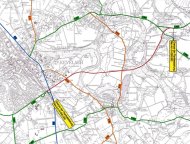
Kevelaer bypass - OW1
For more than 60 years, the people of Kevelaer have been fighting together with politicians and the administration for a bypass to relieve the Rhine road and Winnekendonk. In December 2018, District President Birgitta Radermacher ceremoniously handed over the planning approval decision at the last council meeting of the year. From 22.01-04.02.2019, all interested citizens had the opportunity to view the planning documents in the town hall of the pilgrimage town of Kevelaer, 4th floor.
The planning approval is currently being contested. Straßen.NRW has therefore applied for immediate enforcement of the planning approval, which the Düsseldorf district government has granted. This means that preparatory measures, such as compensatory measures, can begin even before the final ruling.
The OW 1
The Kevelaer bypass(L486n) comprises the new construction of the 5.269 km long Winnekendonk bypass and connects to the already completed Kevelaer bypass(L491). It is part of the east-west connection between the border region to the Netherlands in the west, the A 57 highway( Sonsbeckjunction ) and the Left Lower Rhine region in the east. It is a state road of at least regional importance which, together with the federal highways, is intended to form a coherent network in order to create continuous traffic connections. For the population of Kevelaer, however, it primarily means relieving the traffic congestion on the Winnekendonk and Kevelaer crossroads, especially the Rhine road.
At the same time, a new bypass means that a lot of land is taken up by nature and the landscape. The route will be built with one lane in each direction and will be routed close to the terrain, i. e. max. 1.5 m above the ground. The structures required to cross watercourses are an exception.
| Total land use | 44.72 ha |
|---|---|
| Roads, verges, embankments, new construction of paths | approx. 16.66 ha |
| Compensation for interventions in nature and landscape outside the structure of the road | 28.06 ha, thereof - 12.31 ha in the immediate vicinity of the route - 15.75 ha in the area of the Niers (Niersauenprojekt Kevelaer-Binnenfeld of the Niersverband) |
Route
The route of the bypass was determined as early as 1980, taking into account the proposed alternatives and environmental aspects. In October 1996, the least conflicting corridor for the bypass was sought in a new environmental impact assessment. Three northern and one southern variant were examined. After weighing up the options, it was concluded that the southern variant would result in the greatest reduction in traffic and thus the greatest relief for the residential population. Some modifications in favor of nature could be made in comparison to the route determined in 1980. The route determined in this way forms the basis of the planning approval procedure.
Planning approval procedure
The task of the planning approval procedure is to plan the route in detail, taking into account all planning-relevant aspects. The aim is to minimize the impact on nature and the landscape(Section 13 BNatSchG). It is no longer possible to completely avoid interventions in nature and the landscape, as it would then not be possible to build a bypass. However, the need for OW 1 has already been legally established in the Act on the Needs and Expansion Planning of State Roads(LStrAusbauG). Various mitigation measures are intended to reduce the impact, such as collision protection walls on the bridge structures to protect bats or extra-large culverts to allow the various animal species to pass under the route and thus minimize habitat fragmentation. However, mere mitigation is not enough; there is a need for compensation. Wherever possible, compensatory measures are taken to enhance the directly surrounding nature, e. g. paths that are no longer required are unsealed and recultivated as agricultural land. The renaturation of the Niers is also part of the compensation for the construction of OW 1.
| Important data | Process steps |
|---|---|
| 10.12.2009 | Initiation of the planning approval procedure for the second construction phase of OW 1 |
| 10.02.2010 | Involvement of public agencies( e.g. water and soil association, recognized nature conservation associations, office for the preservation of monuments, etc.) |
| 08.03.-07.04.2010 | Presentation of the planning documents in the town hall of Kevelaer |
| 06.10.2010 | During the public consultation, 58 objections were raised, which were explained and discussed at the hearing. As a result of the objections, the plans were amended. |
| 20.01.2012 | The public bodies, property owners and other parties affected by the plan amendment have the opportunity to comment |
| Preparation of the final planning approval documents including preparation of additional expert opinions | |
| 26.11.2018 | Issuance of the planning approval decision |
| Delivery of the planning approval documents to those who raised objections during the public consultation period | |
| 22.01.-04.02.2019 | Public display of the planning approval documents in the town hall of the pilgrimage town of Kevelaer, 4th floor and on the homepage of the Düsseldorf district government |
| Construction of the OW 1 can begin as soon as the planning approval decision is legally binding; if necessary, a decision on legal action must be made in advance. Lawsuits are currently pending. | |
| 04.11.2019 | Order of immediate enforcement of the planning approval decision of 26.11.2018 for the new construction of the L 486n as the southern Kevelaer-Winnekendonk bypass |
Land consolidation procedure
Land is required both for the construction of the bypass and for the compensatory measures. This land will be acquired and reorganized as part of the land consolidation process in order to minimize the impact on agriculture. The contact for the L486nbypass is Department 33 at the Düsseldorf district government (0211-475-9803; post33@brd.nrw.de).